Coastal cities have always been magnets—ports, trade routes, culture, density, and those priceless “waterfront views.” But the same edge that makes them vibrant also makes them vulnerable. Rising seas are turning today’s nuisance flooding into tomorrow’s infrastructure crisis, while stronger coastal storms push surges farther inland and erode shorelines faster than many communities can repair them.
The challenge isn’t only the ocean getting higher. Many coastal metros are also sinking. Land subsidence—often linked to groundwater extraction, soil compaction, and delta dynamics—creates “relative sea level rise” (the sea rising plus the land dropping), which can outpace ocean rise in some places. Add saltwater intrusion, wet basements, overloaded combined sewers, disrupted transit, and heat-stressed communities with fewer resources to adapt, and the shoreline becomes a pressure point for equity, ecology, and public health as much as for engineering.
From “hold the line” to “live with water”
For decades, the default coastal response was to harden: seawalls, bulkheads, and floodgates. Those tools still matter—especially for critical assets—but more cities are moving toward a more landscape-led idea: make room for water, slow it down, store it safely, and let natural systems do part of the work. The IPCC notes that coastal wetlands can reduce erosion and flooding impacts where there is space and habitat to function, though their ability to keep up has limits if sea level rise outpaces sediment build-up.
Landscape architecture is central to this shift because it treats water as a design medium—something that can be routed, staged, absorbed, and celebrated, rather than simply blocked. The projects below show how different cultures and coastlines are building a new “waterfront normal.”
Coastal resiliency projects around the world
1) Sanya Mangrove Park — Sanya, Hainan, China
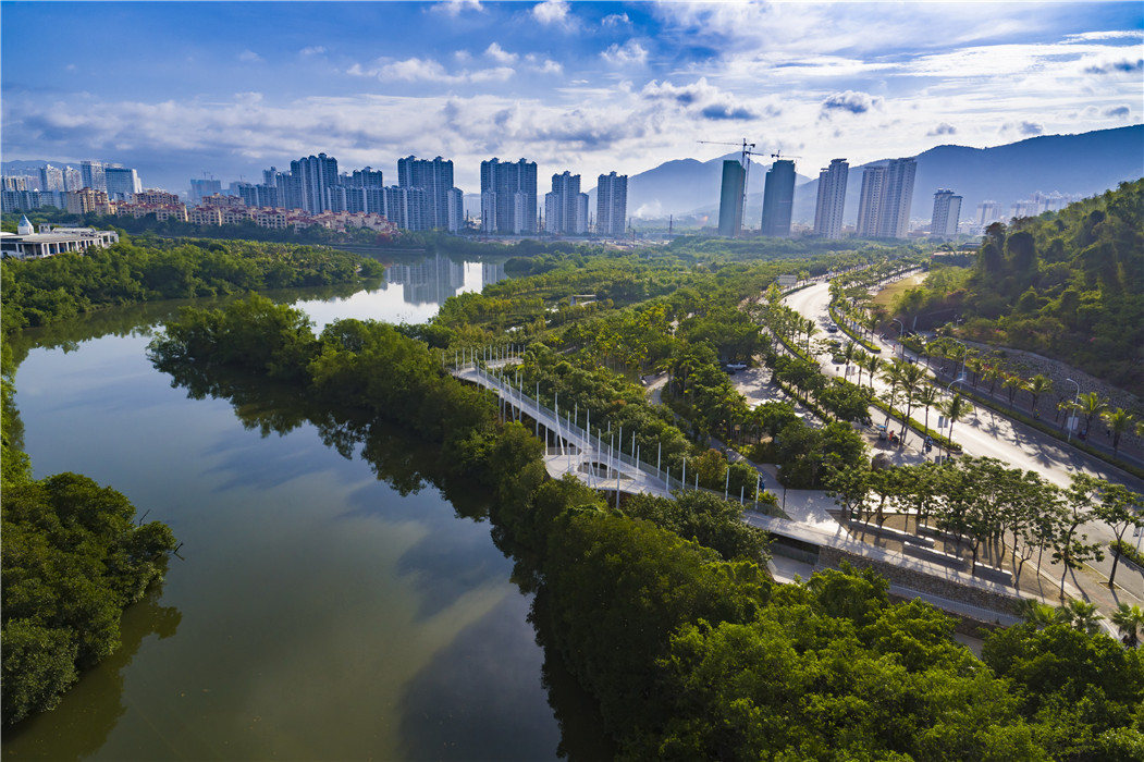
Source: turenscape.com
Turenscape reworked a degraded urban edge into a porous tidal ecotone, prioritizing mangrove rehabilitation and creating access through elevated paths and wetland corridors—inviting tides back into the site instead of sealing them out.
Living-with-water lesson: Resilience can start with restoring the shoreline’s living buffer—replacing hard edges with mangrove systems that absorb, filter, and adapt.
2) The Netherlands: Room for the River (a mindset that transfers to coasts)
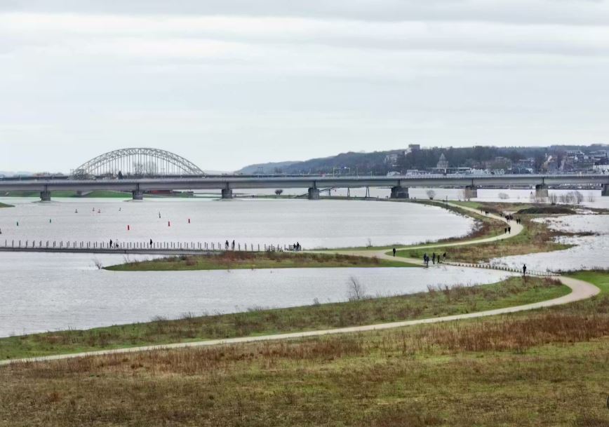
Source: rijkswaterstaat.nl
While not strictly a coastal project, the Dutch “Room for the River” program is foundational to the global “live with water” movement: flood risk is reduced by giving water more space—lowering floodplains, relocating dikes, and creating side channels and bypasses rather than endlessly raising levees.
Landscape takeaway: Resilience isn’t always higher walls. Sometimes it’s strategic retreat and regrading that turns catastrophic floods into manageable, planned inundation.
3) “‘Typhoon-proof’ Shenzhen’s East Coast” — FELIXX + KCAP, Shenzhen, China
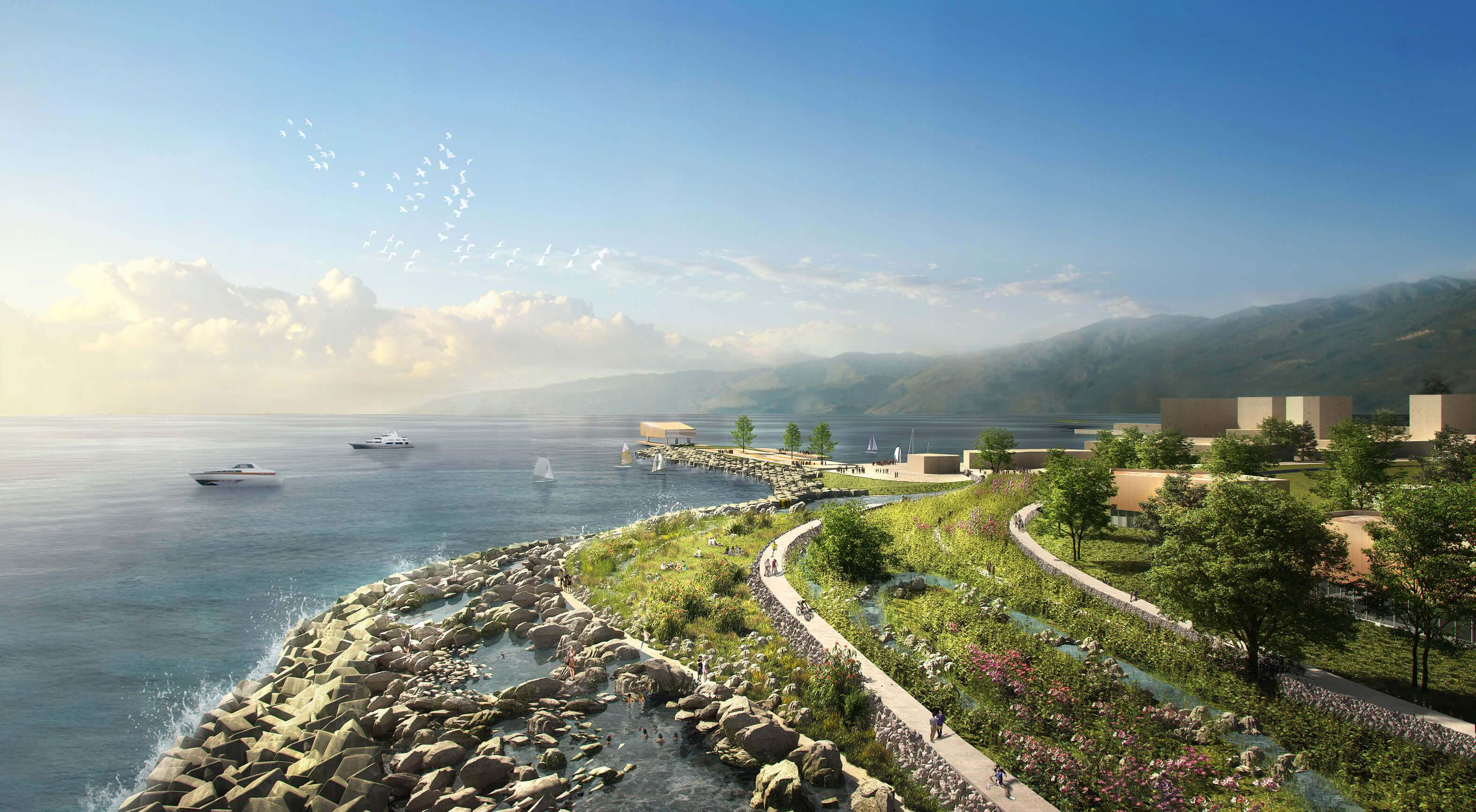
Source: felixx.nl
After Typhoon Mangkhut damaged the Dapeng peninsula’s coastal infrastructure, the FELIXX + KCAP team developed a “Triple Dike Strategy” for roughly 18 km of coastline—moving away from a single hard wall and toward a layered system: an outer zone for wave attenuation/sedimentation, a middle elevated protection line integrated with parks and promenades, and an inner “sponge” layer for rainfall buffering and storage.
Living-with-water lesson: Layered edges create redundancy—and the most “protective” element can also be the most public (a park, a promenade, a tidal landscape).
4) Toronto, Canada: Don Mouth Naturalization + Port Lands Flood Protection (Biidaasige Park)
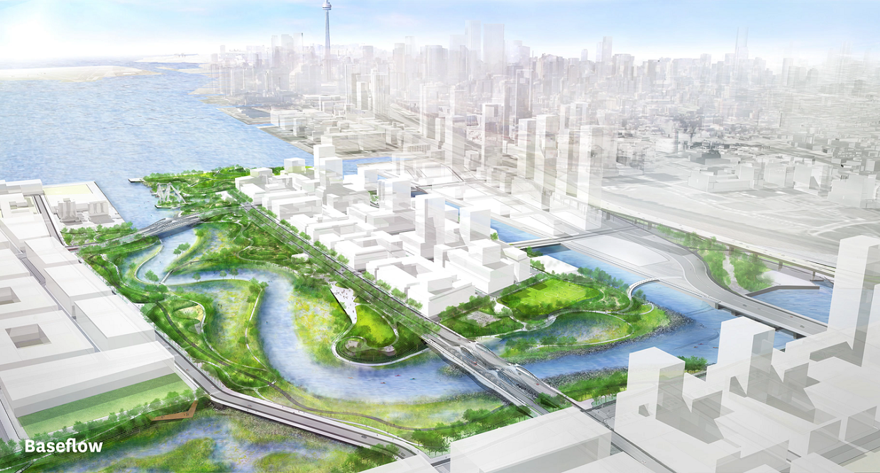
Source: torontorap.ca
Toronto is reconnecting the Don River to Lake Ontario by cutting a new, naturalized river mouth and shaping a floodable river valley with wetlands and aquatic habitat—protecting nearby neighborhoods while delivering major new parkland in the Port Lands.
Living-with-water lesson: Big protection can come from giving water its own landscape—a designed river mouth and wetland valley that safely carries floods while creating everyday public space.
5) London, UK: Thames Estuary 2100 (TE2100)
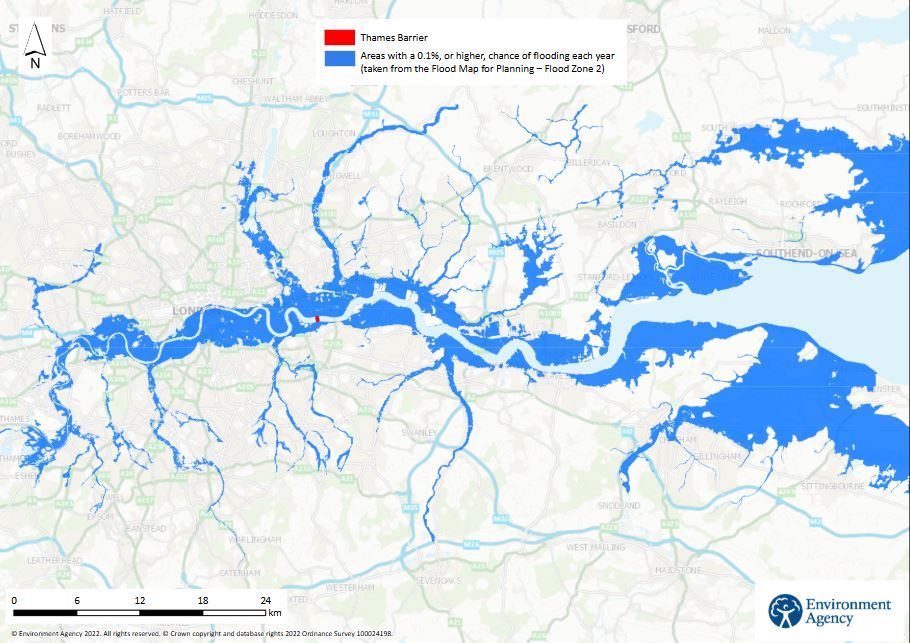
Source: gov.uk
TE2100 is less a single project than an adaptive framework for a changing estuary. It uses an adaptive pathways approach—monitor change, review regularly, and shift strategies over time instead of betting everything on one fixed “end-state” solution.
Landscape takeaway: Your masterplan should anticipate uncertainty. Build in decision points—the landscape equivalent of “future tie-ins”—so the city can evolve as projections sharpen.
6) West Sussex, UK: Medmerry Managed Realignment
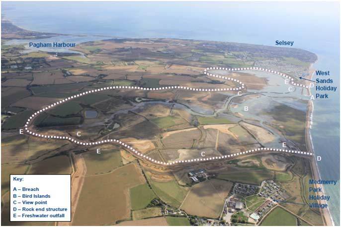
Source: ice.org.uk
Medmerry is a landmark example of stepping back from the coastline: new defenses were built inland, and the seaward zone was allowed to become intertidal habitat. The UK government describes managed realignment as creating new inland defenses while allowing an intertidal area to form in front—turning the coast into a buffer rather than a brittle edge.
Landscape takeaway: Sometimes the most resilient waterfront is not a waterfront at all—it’s a new wetland landscape that absorbs energy, supports biodiversity, and reduces long-term maintenance.
7) New York City, USA: East Side Coastal Resiliency (ESCR)
Born from post–Hurricane Sandy resilience planning, ESCR integrates flood protection into the public realm—elevating and reconstructing parts of East River Park while improving access, bridges, and open space so the neighborhood isn’t simply “walled off.”
Landscape takeaway: Coastal infrastructure can be civic infrastructure. If communities have to live with construction and change, the result should deliver daily value: shade, sport, ecology, safer access, and continuity of neighborhood life.
8) Bangkok, Thailand: Benjakitti Forest Park
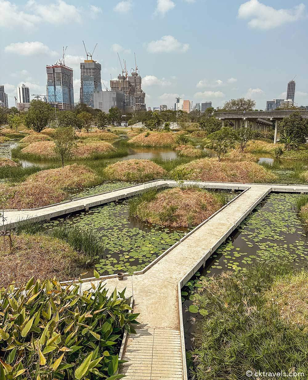
Source: cktravels.com
Built on a former industrial site in a low-lying, monsoon-prone city, Benjakitti operates like a sponge and wetland system: storing stormwater, cleaning inflows through planted ecologies, and allowing parts of the park to inundate without losing its value as a civic landscape.
Living-with-water lesson: Design parks to be floodable on purpose—when inundation is part of the program, water becomes performance instead of disaster.
9) Singapore: Tekong Polder (empoldering + coastal protection)
Singapore is testing Dutch-style empoldering to create land while integrating coastal protection features. PUB (Singapore’s national water agency) describes the Tekong Polder as Singapore’s first polder, using an empoldering reclamation method with coastal protection benefits.
Landscape takeaway: In very space-constrained cities, resilience may come through managed, engineered water landscapes—but the long-term success depends on rigorous operations, monitoring, and public trust in the system.
10) Central Java, Indonesia: Building with Nature in Demak
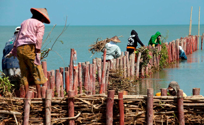
Source: nature-basedsoultions.com
In Demak, “Building with Nature” combines ecological restoration with light engineering—using permeable structures to trap sediment and support mangrove recovery, stabilizing shorelines and reducing erosion risk. This approach explicitly aims to use natural processes rather than fighting them.
Landscape takeaway: When budgets are limited and stakes are high, resilience can be process-based: trap sediment, restore habitat, and let the coastline heal into a new equilibrium.
What these projects have in common
Across climates, politics, and budgets, the most compelling coastal resilience work is converging on a few shared design moves:
- Room for water: floodable parks, intertidal zones, sacrificial edges.
- Multi-benefit sections: protection that doubles as mobility, habitat, and public space (the “park + infrastructure” hybrid).
- Nature-based (and nature-assisted) performance: wetlands, reefs, mangroves—effective when given space and time, but not a silver bullet if sea level rise accelerates.
- Design for uncertainty: adaptive pathways and phased upgrades instead of one permanent “final answer.”
- Make processes legible: visible water storage and “learning landscapes” build public understanding and stewardship.
- Plan for relative sea level rise: include subsidence in the math, not just ocean projections.
The future waterfront is a living landscape
The big idea isn’t that cities can simply “give up” or “hold the line.” It’s that the best coastal resiliency work treats the shoreline as a dynamic border—one that can flex, flood, grow, and adapt. In practice, that means designing places where water is expected, directed, and welcomed in specific ways—so the city stays safe and stays connected to its most powerful asset: the water itself.
